Tourism and GIS: Mapping and Promoting Places
The application of GIS is very encompassing. Various industries can use GIS in different ways; to help them answer a spatial inquiry, to expand the reach of their business, and even to communicate and engage with the public. While most of the pioneer industries and foremost users of GIS are those that are into research, the digital age is slowly bringing in GIS to power up business operations. And in recent years, we’ve been seeing how government agencies are also starting to use GIS to improve public service and develop innovative ways to promote public engagement.
The tourism industry is one of the primary segments of the government that can benefit a lot with the help of GIS. If you can recall, one of the basic functions of GIS and mapping is answering where things are. And this is very helpful especially for industries like tourism wherein, people are always interested to know where the beautiful sceneries are, how to get there and almost all questions, big or small, about a certain place.

A sample web-based tourist map using Esri’s Story Map template.
But how can we use GIS in tourism? Here are just some applications.
Mapping Popular Landmarks / Points of Interests (POI)
There is no doubt that mapping popular landmarks that people can visit in a certain place, is the most obvious application. Today, almost everyone is using a smartphone that can tag the location of a monument or museum for instance. These locations can then be displayed in a printed tourist map, or in an interactive web map that people can view anytime. vMAP can be used by local tourism departments to map these popular places in their area and share it online so people can easily find them while navigating. In vMAP Portal, different map view for a specific theme (instagrammable locations, cultural tours, entertainment) can be created for different types of tourists as well.

Colorful printed map with vibrant design is still a popular medium of communication for tourist maps.
Mapping Unknown Destinations
In relation to the first example, tourism organizations can also use GIS to discover attractions that are currently unknown to the public. Seasoned travelers, especially backpackers usually explore places that they have not been to yet. And these are often the more beautiful ones since only a few know about it. While most people want to visit those that are popular and vibrant places, more travelers are now choosing these serene and peaceful locations where they can relax and have some quiet time alone or with their loved ones.
vMAP can be used as a tool to crowdsource data from these people so others can also enjoy these lovely but off-the-beaten-path attractions. Organizations can develop a web map accessible by the public with an option to add and edit places to engage the public in locating these “hidden” treasures.

Less popular attractions like hidden mountain trails can be mapped out through crowdsourcing.
Trip Optimization
And then of course we have the routing capability in GIS that organizations can use to organize trip stops efficiently, particularly for guided tours where several landmarks are visited within a certain time. GIS can be used to find the optimal routes to visit all the locations in the shortest possible time.
This capability is readily available in vMAP Portal so users can easily plan each route for different types of tours. They can also incorporate specific trip details of the trip like the day of the week or time of day of arrival/departure to optimize the route further, ensuring an enjoyable experience to travelers.

Efficient route optimization can be carried out in vMAP Portal for trip planning.
Planning a New Ecotourism Development
In terms of planning and management, tourism organizations can also use GIS in identifying potential ecotourism destinations. According to The International Ecotourism Society, ecotourism means “responsible travel to natural areas that conserves the environment, sustains the well-being of the local people, and involves interpretation and education” (TIES, 2015). Ecotourism is an emerging trend aligned in the conservation of the environment and promoting sustainable traveling.
GIS can be used to identify potential locations that can be considered ecotourism sites based on different factors. Site planning through overlay analysis i.e. intersect operation can be done in vMAP. The generation of a service area and buffer can also be done in vMAP Portal to detect potential coverage and accessibility of the ecotourism sites in terms of distance and travel time.
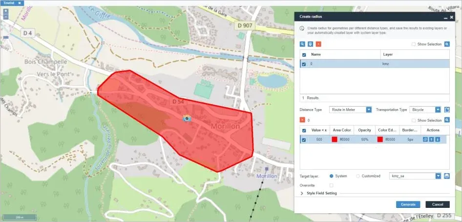
Service area of the potential ecotourism site can be calculated in vMAP. In this example, the red polygon shows the area that is within 500 meters from the site.
Conclusion
These are just some of the most common applications of GIS that can greatly benefit the tourism industry. Of course, there are still a lot of possibilities depending on the needs of the organization. But to boost your organization’s tourism-related initiatives, GIS is undoubtedly one of the best tools that you should be taking advantage of.